Alaska: Wrangell-St. Elias National Park- Iceberg Overlook to Iceberg Lake- Day 5

Alaska: Wrangell-St. Elias National Park- Iceberg Overlook to Iceberg Lake

Total Mileage- 6.04 miles

Total Elevation Gain- 891 feet

Total Elevation Loss- 1889 feet

Screen Shot 2018-12-08 at 8.32.22 PM

Screen Shot 2018-12-08 at 8.48.54 PM

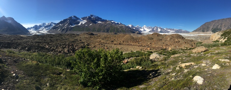
Day 5 in Wrangell St. Elias National Park in southeast Alaska started with a day hike and ended with our trek to Iceberg Lake where the bush plane would be picking us up on day 7. Logistically there was a discussion on how we would play day five. From Iceberg Overlook (where our camp was set) we definitely wanted to do a day hike to find a hidden lake that had Patrick and Josh obsessed. But after the day hike, we discussed camping one additional night on Iceberg Overlook because it was just such a stinking great spot, likely one of my favorite campsites on any trip. But, with some rain likely late in the afternoon we decided to go ahead and make our break toward Iceberg Lake after the day hike.

IMG_4288IMG_0137

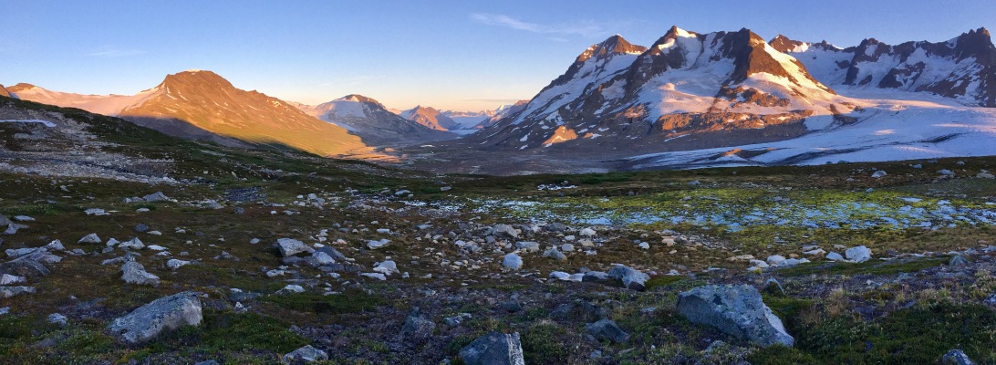
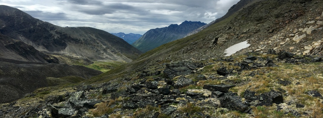
Our day hike took us north northeast away from Iceberg Lake and up about 900 feet. As is typical with Alaska, there were blueberries once again covering every step. I have to admit feeling guilty when backpacking Alaska, because you just can’t walk without stepping on blueberries! Our hiking time doubles because we can’t help but continually stop and forage. So much goodness and abundance. Not to mention that this was a STUNNING hike. The higher we ascended, the more ridiculous the panoramic views became. If you ever make it into this area of Wrangell, figure out a way to spend an entire down day hiking around and exploring. You will be better for it.

IMG_4198IMG_4216IMG_4201IMG_43462234F482-4A39-4C15-987D-C8A2CE3DDB99IMG_4205

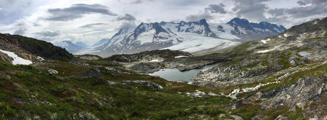
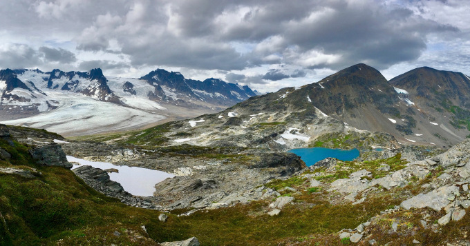
Honestly, there isn’t much to say about this other than… wow wow wow. Out of every trip we have taken… THIS is the most beautiful spot I have ever stood. I could have stayed the entire week in this place.

FullSizeRender 20IMG_4199

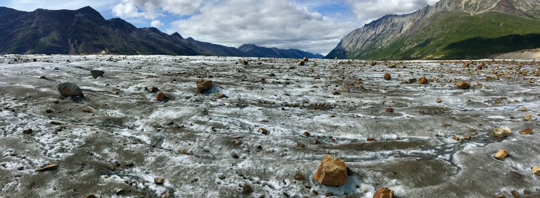
After we broke camp, we began our five mile jaunt to Iceberg Lake. This is where we were planning to camp on night five and day hike from on day six. That plan would change, but we still had to get to Iceberg Lake and find the landing strip. We headed down the gentle slopes of soft, spongy tundra laden with rocks and boulders and it was a pleasant, leisurely trek. That is until we got down to the braided glacial streams that reminded us that Alaska is never to be taken leisurely! While the streams look like you could just jump over them in the pictures, let me assure you that isn’t the case. They are deep and very fast moving. Admittedly, we waste a lot of time trying to find narrow portions that are easier to traverse, rather than just jumping in and going for it. I have said this about other trips, but I hate wet boots. I will jump in, but I always look for an option that keeps my boots dry. But as you soon figure out in the wilderness, you just have to suck it up and get across.

The only hiccup we had with the crossings was that Adam lost one trekking pole a couple of days earlier, which was going to decrease his stability in crossing. I would either lock arms with him on a crossing, or throw one of my poles to him after I had crossed. On this particular section there wasn’t anything that required anything more than trekking poles and a basic understanding of how to cross. The deepest we encountered was just above the knees.

One additional navigational point. As you are traveling south from Iceberg Overlook, I would recommend hugging a bit more toward the west. If you look at the very rough Google Map above, you will see that cutting too far east will get you into trouble, as the terrain gets very step and hard to traverse. Also, if you err toward the east, you will have an incredibly difficult time getting back to the airstrip because the crossings become too difficult. There isn’t any real way to tell you how to do it other than to stay away from the more eastern route.

IMG_4217imageIMG_4223

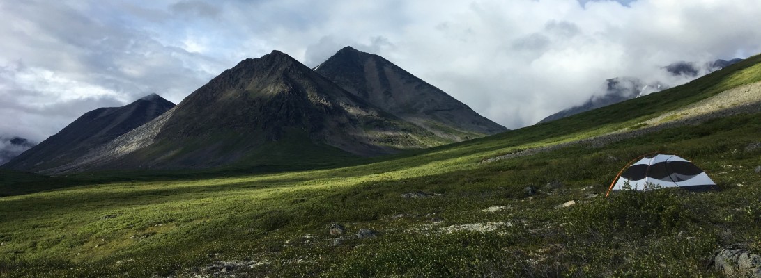
As is typical with difficult sections, I rarely take pictures. Sorry. It was cold and rainy and we were pretty wet from the crossings. After finishing the last portion of stream crossings and getting into the sand, we ducked into a small sand carve out to block the incessant and biting winds, and to also figure out our navigation points. It is at that point that we used the GPS device to check the weather. What we saw was that the rain was going to continue for the next day unabated at 100%. We debated what we ought to do, because the next day was to be a full day of day hikes. We decided to send a text to the bush plane company to see if they were going to be in the area the next day. As it turned out, they would be dropping a group at the exact spot where we would be camping. While it was unfortunate to bail one day early, none of us felt like getting hypothermia. We set our tents up in the sand while it poured rain (yup, nothing there but sand!). After getting off the cold, wet clothing and drying out the tent, I went to bed in my toasty sleeping bag.

The next morning was cold and rainy, as expected, but it wasn’t long before we could hear the low roar of our ride out. Wrangell St. Elias was everything and more and more and more. I absolutely cannot wait to go back there one day.

IMG_4229IMG_4233

Alaska: Wrangell-St. Elias National Park- Bremner Glacier to Iceberg Overlook- Day 4

Alaska: Wrangell-St. Elias National Park- Bremner Glacier to Iceberg Overlook

Total Mileage- 9.1 miles

Total Elevation Gain- 1928 feet

Total Elevation Loss- 918 feet

Screen Shot 2018-08-19 at 5.03.16 PM

Screen Shot 2018-08-19 at 5.05.20 PM

Day 4 in Wrangell-St. Elias National Park in Alaska would take us from Bremner Glacier to Iceberg Overlook. It is nearly impossible to locate names for areas in Wrangell, so I just made up the Iceberg Overlook, being that our campsite for this night faced the direction we would be heading… Iceberg Lake. I don’t recommend doing nine miles of trail-less backpacking in Alaska. Others may disagree, but I find that one mile per hour on difficult terrain is very taxing. And, I am not getting any younger. This particular day was 8 hours and 37 minutes of hiking time. This did not include breaks or lunch time. It was a long day, but one of the most beautifully stunning days we have had on any trip.

The day started brilliantly with exquisite views of Bremner Glacier and once we packed up we headed eastward from craggy rocks into sandy beaches. It was surreal to be in the middle of Alaska and to be walking in the sand in the middle of the mountains. The sand transitioned into a lush green valley floor that we would follow the rest of the day for about six miles.

IMG_4098IMG_4106IMG_4120IMG_4123IMG_4132

There were a few small creek crossings on this stretch. At one crossing we were searching for rocks to hop across (and looking a bit too myopically) and didn’t notice the brown sow with cubs lingering at the same creek about sixty yards from us. Fortunately the mother was pouncing on the ground for some small rodent to notice us. We cleared out of the area, but it didn’t take us long to see where the bears had been before us.IMG_4139IMG_4183IMG_4178IMG_4164IMG_4145IMG_4153IMG_4173IMG_4175

For the most part, the terrain was really straight forward. It was low scrub and soft, mossy mounds that were a little difficult to maneuver through. There was one creek/waterfall that we had to cross closer to our end destination. That is the way it always is in Alaska. I remember that crossing and the jump that had to be made from the last rock to the other side. It had to be a perfect landing… and we all hit it perfectly. The weather was perfect this entire day with highs in the mid to low 60’s F. IMG_4161IMG_4172IMG_4186IMG_4187IMG_4189IMG_4283

The spots where we camped are likely the best spots I have ever had in my life. The ground was soft and spongy underneath with a view that very few will ever see. As you can see from the evening shot above, it was an amazing location. And it got even more epic the next morning. On day five we will do an early morning day hike up to a hidden lake and then make our way toward Iceberg Lake.

Day 5- Iceberg Overlook to Iceberg Lake

Alaska: Wrangell-St. Elias National Park- Bremner Glacier Overlook to Bremner Glacier- Day 3

Alaska: Wrangell-St. Elias National Park- Bremner Glacier Overlook to Bremner Glacier

Total Mileage- 6.8 miles

Total Elevation Gain- 1714 feet

Total Elevation Loss- 1868 feet

Screen Shot 2018-08-19 at 11.18.14 AM

Screen Shot 2018-08-19 at 11.48.26 AM

Day 3 in Wrangell-St. Elias in Alaska took us from the Bremner Glacier overlook down to crossing the Bremner Glacier. The first two miles of this day had the potential of taking up most of our day. I say that because to get down to the glacier we would have to navigate through dense alder. And when I say dense, I mean dense. There were really only two considerations at this point. It was to either take the low route, which would invariably mean that we would be bushwhacking for the next five plus hours. Or, take the high route above the alder and hope for an animal trail that would cut through the alder. After much discussion and blueberry picking, we decided to take the high route and pray for an animal trail. Thanks to Josh Brown on this one, as he scouted out a bear trail that, within one hour, led us all the way down to a one-hundred foot overlook of the glacier where we took a long lunch break. Finding the bear trail was a thing of beauty and a huge time saver.

IMG_3930IMG_3937-2IMG_3932-2IMG_3935-2IMG_3939-2IMG_4064IMG_4068IMG_4072IMG_4446IMG_4074

The easiest route down to the glacier after our lunch break was a rock slide. We followed it down and came face to face with Bremner Glacier, which we had to find a spot low enough to step up onto it. Our trek across Bremner was nothing short of stunning. We had previously watch a pair of wolves run across the glacier during our lunch break, but now we were traversing the glacier ourselves and experiencing its vastness. Alaska always reminds you how infinitesimally microscopic you are when you are swallowed whole by its size. What looked like a quick cross from a higher vantage point, became a few hour endeavor. Our initial plan was to cross the glacier and then take a high route over the adjacent mountain to reach our camp for the day. However, we met a guided group in which the leader encouraged us to stay on the glacier the entire way to our camp. He said it was much more visually stunning. So, rather than beat the bush, we trekked across the glacier…and we were better for it.

IMG_9934IMG_4116IMG_3981-2IMG_3984-2IMG_3987-2IMG_3989IMG_3991IMG_3993IMG_3996IMG_4003IMG_4458IMG_4010

For the most part, this was an easy route. The crevasses were relatively narrow on our path. However, had we taken a more westerly route, rather than a southeasterly route, we would have entered areas that would require technical skill and equipment that we did not have. We simply wanted to cross the glacier for the views and to reach our end destination for the day. As we stepped off of the glacier in that southeastern corner that hugged the edge of a mountain, we could see the height of Bremner and how imposing its accumulation was.

IMG_4021IMG_4530132748BF-6512-4162-921A-20AC4FFDC58DIMG_9993IMG_4286-2IMG_4037

The last portion of this trek led us up and away from the glacier on top of a rocky shelf. The campsite we chose had a brilliant view of the towering edges of the glacier. Our next day would take us through a staggering valley and closer to our end point at Iceberg Lake.

Day 4- Bremner Glacier to Iceberg Overlook

Alaska: Wrangell-St. Elias National Park- Monahan Creek to Bremner Glacier Overlook- Day 2

Alaska: Wrangell-St. Elias National Park- Monahan Creek to Bremner Glacier Overlook

Total Mileage- 8.83 miles

Total Elevation Gain- 1475 feet

Total Elevation Loss- 2350 feet

Day two in Wrangell-St. Elias National Park would take us from the Monahan Creek area to a beautiful overlook of the Bremner Glacier, which we would be tackling on Day three. The day started out in classic Alaskan style- gray skies, low hanging clouds, and rain. The goal for the morning was to stay above the brushy areas, but stay below the loose and steep scree areas. If this is done correctly it will be relatively easy trekking across some basketball-sized rocks. The key is to work your way down the valley with an eye toward the Monahan Creek junction and the saddle which you will be passing over. The best advice is to minimize areas of alder while working your way toward Monahan Creek. We had to search for a while to find a spot to cross over the creek, but eventually found some stepping stones that kept us from getting our boots wet. That was a huge win. But you have to keep your eyes open, because much of the area has steep walls to the creek or water moving too powerfully to cross.

Upon the creek crossing we were on our way over the saddle that would lead to Bremner Glacier. We had to make a decision on how far we really wanted to go on this day. If we went too far, we would commit to several hours of dense alders that descended to the glacier. Did we really want to end the day with that kind of battle? If we went into the alder for the remaining part of the day, would there be anywhere to camp without having to commit to crossing the glacier in the same day? Committing close to nine untrailed, Alaskan miles before the alder and glacier seemed like enough for one day. So we knew that the next day was going to be the monster day- alder/glacier. At least we would have the evening and night to mentally prepare for it. Dense alder will make you wish you were back on the dirt trails in Indiana. I have yet to find a fan of alder bushwhacking. Nonetheless, the terrain for this portion of Day 2 was ideal for backpacking, but the boulders heading up to the saddle was a little work.

Once we hit the saddle we could see where the dense cloud cover was coming from- the glacier. And we saw for the first time… blue skies. As I mentioned in the previous post, the Bremner area from which we came seems as if it gets a lot of cloud cover and rain, likely due to the cold air coming from the glacier. Am I no meteorologist, so I am likely wrong, but on subsequent days we would look back and see gray skies and rain even though we were in clear skies. The green in front of us was a beautiful, but I am not sure how to classify it. It was a somewhat marshy area with a mixture of knee-high scrub, longish tussock, and scattered alder. The issue, as you can imagine, is where to set up a tent. If there was a spot clear enough for a tent…it was marshy. To be honest, even though it wasn’t a huge issue, I feel like finding spots to camp throughout the week took some work. It’s not like you can just pop a tent anywhere. Most areas were overgrown or rock strewn or not close to fresh water, etc. On this day we had to make due with a bit of an angle, which made for a cool pic below, but it was really the best we could do. I think the other guys got to the flat spot before us and we got the consolation angle. I slept well regardless.

The next day, Day 3, would take us through the alder and down to Bremner Glacier for one spectacular day.

Day 3- Bremner Glacier Overlook to Bremner Glacier

Alaska: Wrangell-St. Elias National Park- Bremner to Monahan Creek- Day 1

Alaska: Wrangell-St. Elias National Park- Bremner to Monahan Creek

Total Mileage- 6.24 miles

Total Elevation Gain- 2673 feet

Total Elevation Loss- 2391 feet

Wrangell-St. Elias. That’s enough to get your heart pumping and your blood rushing. Just the name of it. And all it takes is a little bit of research to realize that this behemoth of a National Park is everything you imagined it would be- towering mountains, braided rivers, pulverizing glaciers, and the most unadulterated peace and beauty you have ever seen in your life.

If you need more convincing that this, this trip isn’t for you.

With a four-hour time difference between Alaska and Indiana, we were ready bright and early, but it seemed as if our morning took forever. We had everything strapped up and ready to go hours before we were to meet up with Wrangell Mountain Air for a shuttle over to the airfield. Once the shuttle arrived at the main office of Wrangell Mountain Air, which is on the main dirt road in McCarthy, it only took us about 25 minutes to get to the airfield. We unloaded the packs and took them over to the bush plane, the DeHavilland Beaver (aka The Beaver). We gave the pilot our bear spray and he duct taped them to the wing of the plane, so we didn’t have any crazy mishaps during the flight, and then threw our packs in to be secured for our fifty mile ride to Bremner.

Despite the blue skies at take off, the weather quickly changed as we got into the mountains. I’m not sure what the weather is like in Bremner typically, but it seemed like it’s own little weather systems consisting of continual gray clouds and a misty rain. That is what we experienced once we landed, into the next morning, and even as we looked back in that direction on subsequent days. Being that there are no trails in Wrangell-St. Elias, all trekking would be done with the assistance of USGS Topo Maps (Bering Gl. D6, D7 and McCarthy A6, A7) to serve as a guide as to our route and direction. In preparation this trip we purchased Falcon Guides Hiking Alaska’s Wrangell-St. Elias book that details the Seven Pass Route from Iceberg Lake to Bremner, but as I mentioned in the last post, we decided to do the route backwards. We decided to go the opposite direction after talking to some locals several months in advance and then determining that we wanted the “most epic” portion of our hike to be at the very end. This choice made the book a little more difficult to understand because it was written going the other direction. Nonetheless, if you decide to do this route… I would recommend the way we did it because of the views. The one thing I can tell you about this route, you are not going to find much information about it, which makes this trip a little more epic in my opinion. You truly have to do it on your own.


Our goal for the day is to head in a southerly route and hit a shoulder to the southeast. It’s really easy to spot, if you are paying attention, but if you miss the turn you will go out of your way to get around this small range. The initial portion of this route from Bremner is easy hiking with low scrub and brush with the occasional boulder field. For the most part we avoided walking through the boulders by staying on the outer edges, but we did have an occasional short stomp through the rocks. This area is just a warm-up to what is coming later in the trip with car size boulders for miles, but for today it is an easy trek for the first two miles when we hit our cut through.

As we ascended our route began to take a northeastern turn, all of which was really great trekking terrain. Compared to our prior experience in Denali, there were very few obstacles thus far in Wrangell. Of course, later in the trip there would be significant alders to contend with but for this first day we welcomed the easy route. The colors, even on this mostly overcast day, were nothing short of spectacular. The air was clean and crisp and we took it all in with every breath. This is everything you imagine Alaskan backpacking to be and more.

The final push for Day 1 would drop down into a valley through which Monahan Creek runs. Being that we really couldn’t plan camping spots in advance, our plan was to hike about six miles each day and then look for a flat area close to fresh water and hopefully a decent (or great) view. The only way we were going to get anything close to a flat spot close to fresh water was to drop all the way down to the valley floor and look for a spot among the alders. While we were still relatively high up, we eyeballed some areas that seemed to open up in the bush. We determined that the darker green areas were high bush and the lighter area were flatter areas with little bush. We just didn’t know how much the difference would be until we got down to it. After working our way through the maze of alder, we ultimately made it to the spot we had scouted. It wasn’t as ideal as we had hoped, as it was still a little more brushy than we would have like, but after looking around for a few minutes we landed a nice spot to through up the tents.

Our trek on Day 2 will take us from Monahan Creek area to our first view of the stunning Bremner Glacier, which we will cross on Day 3.

Day 2- Monahan Creek to Bremner Glacier Overlook


Preparing for a Wrangell-St. Elias Backpacking Trip

The average person has never heard of Wrangell-St. Elias National Park in southeast Alaska, even though it is six times larger than Yellowstone National Park, sizing in at a mere 13 million acres. The sheer size of Wrangell-St. Elias makes it the largest national park in the United States and one of the most prized backpacking bucket list adventures in the world.

Preparing to backpack Wrangell-St. Elias can be daunting. The size, the remoteness, the logistics, and the unknown may be too much for a backpacker who is ready to take it up a level in epic backpacking. But let me assure you that, outside of the logistics of planning this multi-day adventure being a bit challenging, you can do a Wrangell trip with the right mindset going into it.

MINDSET

I feel like we had a bit of an advantage, having backpacked for a week in the backcountry of Denali a few years prior. Even though they were relatively different trips, we knew that Alaska could throw any and every challenge and obstacle at you throughout the week. Leading up to this trip I just kept saying, “Backpacking Alaska is 90% mental and 10% everything else.” It may be a little exaggerated, but trust me, you will do yourself a huge favor if you go in with the mindset that there will be times when you will be cold, wet, tired, sore, and frustrated (of course, everyone at different degrees), but you get the point. Go into Wrangell-St. Elias with the right mindset. This is the best advice anyone can give you. If you expect a difficult trip with obstacles, you have already taken a huge step.

LOGISTICS

Before you do anything else, go to the website of Wrangell Mountain Air. They offer a variety of services, but for our purposes, they fly backpackers into the Wrangell backcountry and drop them off at their specified drop point and then pick them up at their agreed upon end destination. Their website not only describes the different backcountry routes, it shows the areas where they have landing strips for the bush plane.  In essence, you will be backpacking from one landing zone to the next landing zone. You choose the route you will take and the number of days you are planning, just make sure you are at your pickup point on time.  After reading the description and discussing how many days we would be able spend in the backcountry, we chose the Seven Pass Route, which is listed as a trip from Iceberg to Bremner. After a bit of additional research, we decided to travel the opposite direction from Bremner to Iceberg. Once you agree upon the particular route you are going to take, I would suggest calling Wrangell Mountain Air and getting on the books for those dates, as it seems the activity in that area has been picking up over the last couple of years. It is an easy phone call. Just give them your info, your dates, and a 50% deposit and you are set. Wrangell-St. Elias National Park does not require any fees or permits. Yes, I know, that is amazing! But it’s true. All you have to worry about is getting there!

We flew into Anchorage, which was easy, but the real question is how to get to McCarthy, Alaska. It is a seven hour drive with the last hour or two on gravel road. I can tell you that after researching all of the options for getting to that area, the most flexible and cost-effective method is to just rent a vehicle, if you are cool with driving for seven hours. You will need to make sure that you rent an SUV with some heavy duty tires and a spare. I wouldn’t really anticipate any problems on the drive, as the roads (including the gravel) were actually pretty good. We didn’t have any situations over the seven hours in which we felt as if our tires would be compromised in any way. There are other ways of getting to the McCarthy area, but we found this to be the method that fit us the best. You may need to check with the rental company to make sure you can drive the vehicle on gravel roads, but we didn’t have any trouble getting a rental from National Car Rental.

We arrived into McCarthy one day before our trip was to start, which meant that we needed to have overnight accommodations. I highly, highly, highly recommend McCarthy Bed and Breakfast. We loved this place so much, we stayed another night after we finished the trip. This husband and wife team have a variety of little cabins that he built himself. For the four of us, we stayed in a two room, four bed cabin. The location was perfect, as well, as it was a ten minute walk to where we would be picked up by Wrangell Mountain Air the next day. Additionally, the bed and breakfast has an AMAZING breakfast consisting of homemade muffins (try the blueberry muffins!!!), greek yogurt, fresh fruit, hard boiled eggs, granola, cereal, good coffee, etc. It was the PERFECT pre-backpacking breakfast. All four of us highly recommend this B & B.

McCarthy is a very, very, very small community, consisting of no more than 50-70 people depending on the time of year. It is a simple, single dirt street with a variety of businesses lining the street. We recommend eating at a restaurant called Potato. I think we ate there two or three times. Make sure you order the Rosemary Garlic Fries!

The last logistical element that you need to consider is fuel canisters and bear spray. Being that you can not fly with either on commercial airlines, you will need to figure out how to secure them once in Alaska. To be honest, this was the hardest logistical task for us. We arrived in Anchorage and secured the rental vehicle about three hours before the REI in Anchorage opened and we did not want to waste time waiting for it to open. If you arrive in Anchorage during normal business hours, you can just go to REI. If you end up in a situation like us, you will need to do one of two things. Either order online ahead of time or buy the stuff in McCarthy. BUT I need to tell you that I would not wait until you arrive in McCarthy to but these items. I called a couple of the stores a couple of months in advance and they told me that they did not have fuel canisters or bear spray. But when we got to McCarthy one of the stores did have them. BUT I would NOT depend on them having what you need. Did I mention how small McCarthy is? If I understood correctly, the only have a supply plane bring in goods twice a week… and it isn’t guaranteed that they will have specifically what you need.

We ended up ordering both items online, which was tricky as well.  The ONLY online retailer who would ship fuel canisters and bear spray was walmart.com. Other online retailers would not ship combustible items to Alaska (maybe because they would have to be flown?).  Anyway, we asked Wrangell Mountain Air if we could have the items shipped to them and they agreed. The items arrived there about a month before. It worked perfectly.

GEAR

If you are planning for this trip to Wrangell-St. Elias, you should already be well-versed in how to pack for a trip with variable weather conditions, so I won’t go through the entire list. Here are a few things that you may just want to consider. If your trip, like ours, involves glacier crossings, you may want to consider getting some Katoolah micro-spikes. We did not end up using them, but I also slip one time and bruised up my ribs, so it is up to you. The glacier we crossed was non-technical so it didn’t involve any technical gear. If you are close to needing a new pair of boots, I would recommend going ahead getting new boots in advance and breaking them in before this trip. I had about 600 miles on my boots and the lugs were not as grippy as I would have liked for this trip. The terrain is tough and you really need to have a pair of boots that are dialed in and up to the challenge. Once we finished our trip, I retired my boots and bought some new ones. I can’t think of anything else that really stood out from a gear perspective. Maybe just make sure you have some lightweight dry bags in your pack with a dry pair of socks and thermal layer. If you get cold and everything else is weight, at least you will have some dry, warm gear. We also took an emergency satellite beacon that would check the weather, mark our route online for family, and text out if we needed to communicate. That came in handy for our trip, but more on that in a later post.

Those are the biggies, I think. If you have specific questions, just comment below and I will answer them the best I can. You will not regret this trip. It was definitely one of the top trips we have ever taken.

Here is the details and review of each day from Bremner to Iceberg Lake.

Day 1- Bremner to Monahan Creek

Day 2- Monahan Creek to Bremner Glacier Overlook

Day 3- Bremner Glacier Overlook to Bremner Glacier

Day 4- Bremner Glacier to Iceberg Overlook

Day 5- Iceberg Overlook to Iceberg Lake

Brandon

Reblog: All Creation Sings

Hey lovers of the outdoors!

I wrote a new post on my other blog entitled All Creation Sings.  I recount a specific moment in Alaska when summiting Mt. Eielson when I saw Denali for the first time.  It is a faith post, so if that’s not your thing you may choose to disregard… but I thought you each would identify with the emotions that I share in the post.

Btw… I am heading to Wrangell St. Elias NP in Alaska at the beginning of August for a week in the wilderness.  New trip reports will be coming then.

Peace…

Brandon

Alaska: Wolverine Creek (Unit 13) to Eielson Summit and Exit (Unit 13) Denali National Park- Day 7

Wolverine Creek (Unit 13) to Eielson Summit and Exit (Unit 13)

Mileage- 9.2 miles

Elevation Gain- 3750 feet

Elevation Loss- 2700 feet

Day 7 Denali 2

Day 7 Denali

Day seven backpacking in Denali National Park was one of the most unbelievable and memorable experiences in all of my backpacking experience. We spent the previous night at Wolverine Creek with the plan of summiting Mt. Eielson and then camping near the Thoroughfare River with a short exit to the Eielson Visitor Center on the morning of day eight.  As it turned out, we ended up exiting the evening of day seven… but more on that later.

We knew that day seven would be a marathon of a day… so we started off early.  As soon as we popped our heads out of our tents we could see that it was going to be the best day of the week.  Prior to this day we had not had a clear view of Mt. McKinley.  Either the clouds covered it or we were not within view, but this day would be remarkably different.

IMG_3666 IMG_3667

100_2811

We followed Crystal Creek and headed toward Castle Rock.  Had it been overcast that day, Castle Rock would have looked ominous as we headed toward it.  Nonetheless, our plan was to hook just left of Castle Rock and pass over a saddle where we would empty the heavy contents of our packs (bear canisters, tents, sleeping bags and pads) and then summit Mt. Eielson.  Of course we would have to backtrack just a bit when coming down Eielson to pick up our gear, but it was significantly less effort doing that than climbing Eielson with full packs.

IMG_3668 IMG_3669

As I have mentioned in previous posts, backpacking in Denali is challenging because there are not any trails in the backcountry.  I suppose there could be some recommended routes in certain units, but the trail-less nature of Denali evokes a wild and primal instinct- You are free to roam.  And while that creates more of a challenge going from point A to point B… it is completely worth it.  Ascending Eielson evoked that sense for sure.  After dropping the heavy gear and standing face to face with Eielson, we studied the contours and textures, the obstacles, and the grades… and then we went for it.

IMG_3670 IMG_3673 IMG_3675

One of the greatest and most unexpected surprises appeared to our left as we climbed with heavy breath.  The first time Mt. McKinley caught my eye was when I stopped to catch my breath.  When I caught sight of the great Denali… everything stopped.  It was glorious, even from 35-miles away.  The blue skies and the Cirrus clouds painted a backdrop that I will never forget.  We could not get to the top of Eielson quick enough.  We knew our best view would be at the very top, but the grade was becoming increasingly steep and the softball to volleyball sized rocks were becoming increasingly unstable.  With each step we had to be certain that the rocks were stable.  Our trekking poles were invaluable, except for Josh who accidentally left his poles with the heavy gear.

IMG_3676 IMG_3678 IMG_3680 IMG_3681 IMG_3690 IMG_3691 100_2861

At the top of Eielson we separated along the ridge line and spent close to an hour alone, in solitude. Obviously we wanted some time to ourselves to simply take in and appreciate views which others could only imagine. But more than that, we spent time giving thanks to God for such profound beauty and freedom in the world and in our lives, thanks for the gracious and loving family members who support us and let us use our vacation time for wild and mind-blowing trips, and thanks for the physical ability and outdoor knowledge we have that enables us to go into the wild. When we came back together we took some pictures and then each one of us took turns standing on Eielson’s peak yelling to the top of our lungs “ALASKA!” That was the exclamation mark on one epic and memorable Alaskan adventure.

100_2870IMG_3696

IMG_3698

IMG_3700

IMG_3701

IMG_3704

As we descended along the ridge line we could see storm clouds brewing. On our last day Alaska would not allow for an easy exit… and that certainly became our running joke for the last four hours that day. It was a rough descent down the mountain and it seemed as if we would never reach the river bed. It began to rain so we dropped the packs and rain geared up. It stopped raining so we dropped our gear and took off the rain coats because they were getting too hot. We got ever closer to the river bed and decided to stop for our last blueberry break. We dropped the packs again and devoured pounds of blueberries. Once we hit the river bed it was going to be a long haul to our final destination… and around each bend… there were more bends and more bends. We finally climbed a twenty foot hill to the west of us to get on top of the land mass we were trying to circumvent. Once on top we hit a straight line and probably cut out a mile’s worth of river bed hiking. We descended and finally approached the Thoroughfare River. It was our last crossing and we sized it up. Again Alaska was laughing. Although we all had dry boots and wished to finish with dry boots… there was no way to cross without going at least knee deep. Like three banshees we ran through the Thoroughfare like runners crossing the finish line.

IMG_3707

IMG_3710

IMG_3711

IMG_3715

IMG_3717

IMG_3718

IMG_3720

IMG_3721

IMG_3724

IMG_3725

We finally reached our destination for the night, which was only one mile from Eielson Visitor Center. As we dropped our packs and began to shape up the area the rain began to fall again and we just looked at each other. We were each thinking the same thing- we are only one mile from a bus out of the park, a cozy bed, and a warm meal at a restaurant! We were outta there. Sure we would have liked to brag about 8 days in the Alaskan wilderness, but 7 sounded just fine. The rainy and muddy hike up to the visitor’s center was a cruel joke and one last way Alaska would put the screws on us. This was NOT a leisure trail. It was near vertical and four inches of mud to step through on the horizontals. The weeds were head high and so we bush whacked. By the time we reached the top we were informed by a ranger that they had just spotted a grizzly in the immediate area in which we were hiking. Of course. We waited 15 minutes for a green bus to pick us up. I am sure the people we sat near did not appreciate our looks or smells.

Would I recommend someone backpack in Denali National Park for a week? Absolutely. But only if you have your head straight. While this was the most labor intensive backpacking I have ever done, it was more of a mental challenge than anything. Despite how difficult it was, it was one of the most beautiful and rewarding accomplishments in my life.

An edited, day-by-day version of my adventure in Denali National Park appeared in the fourth issue of Sidewalk – a hiking and backpacking magazine.

Alaska: Muldrow Glacier (Unit 19) to Wolverine Creek (Unit 18) Denali National Park- Day 6

Muldrow Glacier (Unit 19) to Wolverine Creek (Unit 13)

Mileage- 5.1 miles

Elevation Gain- ~500 feet

Elevation Loss- ~500 feet

Day 6 Denali

Day 6 Denali 2On our sixth day in Denali National Park we left Unit 19, crossed the Muldrow Glacier to Green Point (for the second day in a row), and then hiked into Unit 13 to Wolverine Creek just south of Mt. Eielson.

I have to be honest and say that my two favorite days in Denali were days six and seven.  Of course I will write about day seven in the next post, but day six was something else.  We woke up to a few clouds, blue skies, and a warm, radiant sun.  We welcomed it, for sure.  The previous day we were completely soaked and spent much of the evening in our tents.  On this morning we were able to set out all of our wet gear to dry.  We knew that we only had about a five-mile hike so we were cool with getting a later start.  And, despite getting off track the previous day crossing the Muldrow Glacier… we were much more confident  crossing the glacier with a direct route to Green Point this day.

IMG_3576IMG_3598 IMG_3601 IMG_3605 100_2635

This biggest issue with crossing the glacier is when you drop down and lose your line of sight to the end destination. As we planned our crossing, we made mental notes of identifiable landmarks within the glacier that would keep us lined up. I suppose a simple compass would do the same thing, but we are guys right? And who wants to ask for directions when we can find it on our own! 🙂 This approach worked just fine. We stayed lined up as we kept our eyes fixed on our intermediary landmarks. Of course the biggest problem with crossing glaciers is the unpredictability of obstacles. Heading toward Green Point we hardly had any real obstacles except for walking around pools of water and going down steep embankments. All of the elevation we encountered on this day was due to the glacier. My guess is that we were under 500 total feet elevation but it may have been just above that. Either way it was easy elevation.

IMG_3608IMG_3609100_2646 100_2647 IMG_3611 IMG_3612 IMG_3614 IMG_3616100_2668IMG_3623

Once we got to Green Point we followed Glacier Creek north until we saw the base of Eielson to the north.  We travelled eastward and just south of Eielson, which we would be summiting the next morning.  McKinley had been elusive for our first six days either because we were out of range or because the clouds covered her.  The park claims that only 30% of all visitors to the park get a chance to see McKinley.  Our best chance would be on top of Eielson.

IMG_3633 IMG_3637 100_2680 100_2686

We followed fresh water of Wolverine Creek through a rock-bed carve out between mountains where we would be camping for the night.  Despite the fact that we wanted to be done for the day so we could pump and eat, we pressed on so that our hike to the saddle on the southeast side of Eielson would be shorter the next morning.  We would be dropping our gear on the other side of the saddle the next morning so that we could ascend Eielson without much weight on our backs.  Finding a spot to camp along Wolverine Creek was not easy because of the rocks and uneven terrain.  We pressed on until we found a spot that could handle our two tents.

IMG_3649 IMG_3651 IMG_3653 IMG_3658 IMG_3659 100_2712

We pumped, ate, and settled down for a much needed night’s rest to prepare for the 11-mile marathon hike up Mt. Eielson and then out to the Eielson Visitors Center. Our most epic day awaited us.

An edited, day-by-day version of my adventure in Denali National Park appeared in the fourth issue of Sidewalk – a hiking and backpacking magazine.