Canada: Great Divide Trail- Sunset Pass TH to Pinto Lake- Day 1

Canada: Canadian Rockies- Sunset Pass TH to Pinto Lake

Total Mileage- 8.50 miles

Total Elevation Gain- 2608 feet

Total Elevation Loss- 1742 feet

The Canadian Rockies! When a person thinks of the best backpacking and most stunning terrain in Canada, Jasper National Park in Alberta is always at the top of the list. Our plan for this 7 night/8 day, 100-mile adventure was to hike from Sunset Pass TH to Pinto Lake where we would hop on the Great Divide Trail and then end our hike on Skyline Trail, which is considered to be the best route in Alberta. Day 1 would take us from the Sunset Pass trail head to Pinto Lake.

Here is a link and free download to the GDT Map Atlas that we used to plan this trip. You can see Pinto Lake on the map above. Our route on the Great Divide Trail (marked in yellow) started on map E50 and counted upward (E51, E52, etc.) Please note that the mileage markers on the map are in kilometers, not miles.

We flew into Calgary, got a rental car, and made a quick trip to the MEC to pick up some bear spray and a few other accessories. MEC is the Canadian equivalent to REI. It is thirty minutes from the airport and along the route to Jasper. As an FYI, you may want to do some research into purchasing bear spray in Canada. If my memory serves me correctly it was quite a process which involved paperwork and a driver’s license. Our plan was to make the five-hour drive to Jasper and stay at the Best Western, which was a couple of hours from the trailhead, and start the hike early the morning of August 3. If you stay in Jasper you need to check out Bear Paw’s Bakery for some amazing pastries and coffee.

We took Highway 93 from Jasper to Sunset Pass TH. This particular trail is not a part of the Great Divide Trail, but connects to it at Pinto Lake where we would be setting up camp for the night. Let me tell you… there is nothing better than driving for five hours, parking, and then immediately starting hiking UP! For Indiana boys who live at 650 feet above sea level, jumping onto a trail a mile above sea level and immediately climbing to 7300 feet is really something for the lungs.

The good thing about our route was that it was all really well maintained and never too overgrown. Compared to the off-trail trips we have done in the past this trail was easy walking. Crossings were made easy through bridges and the dense scrub was easily navigable.

At about the five mile mark we finally got above the tree line and caught an absolutely spectacular panoramic view from above Pinto Lake. When I think back about this area it reminds me of a hybrid between the sawtooth mountains of Glacier National Park in Montana and Denali National Park’s expansiveness.

The trail goes down to the north side of Pinto Lake and is a little over two miles from the highest point. As you can see from the map above, once you connect at the Great Divide Trail juncture there are camping spots near the lake. For Pinto Lake camping there are not any permits to purchase. I didn’t get any pictures of the camping area (sorry), but I believe there were plenty of spots to camp.

Day 2 will take us from Pinto Lake along the Great Divide Trail in the White Goat Wilderness to Cataract Pass.

I Am Back

Sorry for my looong absence on this blog. I have been busy with other writing projects, i.e. my first novel which I finished a few months ago.

Now that I am finished I plan to update with the last THREE TRIPS I have taken: The Canadian Rockies, Wind River Range (2nd Attempt), and the Pacific Crest Trail (Sections in Washington State).

We are also planning an 80-mile trek along a section of the Colorado Trail for August 2021.

Thanks for being patient!

Brandon

Alaska: Wolverine Creek (Unit 13) to Eielson Summit and Exit (Unit 13) Denali National Park- Day 7

Wolverine Creek (Unit 13) to Eielson Summit and Exit (Unit 13)

Mileage- 9.2 miles

Elevation Gain- 3750 feet

Elevation Loss- 2700 feet

Day 7 Denali 2

Day 7 Denali

Day seven backpacking in Denali National Park was one of the most unbelievable and memorable experiences in all of my backpacking experience. We spent the previous night at Wolverine Creek with the plan of summiting Mt. Eielson and then camping near the Thoroughfare River with a short exit to the Eielson Visitor Center on the morning of day eight.  As it turned out, we ended up exiting the evening of day seven… but more on that later.

We knew that day seven would be a marathon of a day… so we started off early.  As soon as we popped our heads out of our tents we could see that it was going to be the best day of the week.  Prior to this day we had not had a clear view of Mt. McKinley.  Either the clouds covered it or we were not within view, but this day would be remarkably different.

IMG_3666 IMG_3667

100_2811

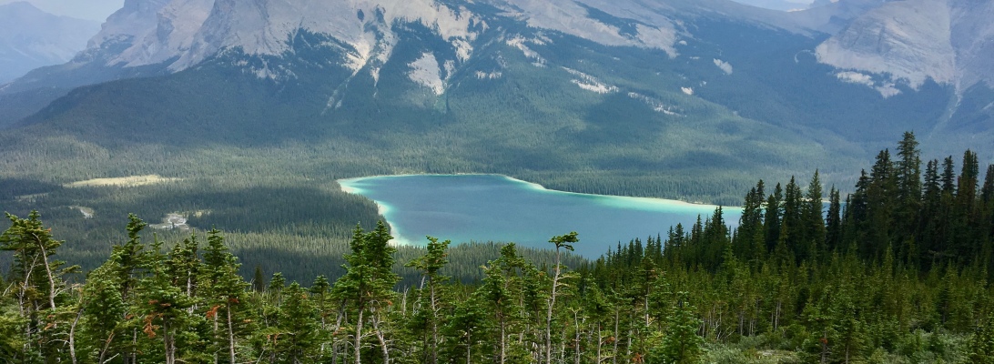
We followed Crystal Creek and headed toward Castle Rock.  Had it been overcast that day, Castle Rock would have looked ominous as we headed toward it.  Nonetheless, our plan was to hook just left of Castle Rock and pass over a saddle where we would empty the heavy contents of our packs (bear canisters, tents, sleeping bags and pads) and then summit Mt. Eielson.  Of course we would have to backtrack just a bit when coming down Eielson to pick up our gear, but it was significantly less effort doing that than climbing Eielson with full packs.

IMG_3668 IMG_3669

As I have mentioned in previous posts, backpacking in Denali is challenging because there are not any trails in the backcountry.  I suppose there could be some recommended routes in certain units, but the trail-less nature of Denali evokes a wild and primal instinct- You are free to roam.  And while that creates more of a challenge going from point A to point B… it is completely worth it.  Ascending Eielson evoked that sense for sure.  After dropping the heavy gear and standing face to face with Eielson, we studied the contours and textures, the obstacles, and the grades… and then we went for it.

IMG_3670 IMG_3673 IMG_3675

One of the greatest and most unexpected surprises appeared to our left as we climbed with heavy breath.  The first time Mt. McKinley caught my eye was when I stopped to catch my breath.  When I caught sight of the great Denali… everything stopped.  It was glorious, even from 35-miles away.  The blue skies and the Cirrus clouds painted a backdrop that I will never forget.  We could not get to the top of Eielson quick enough.  We knew our best view would be at the very top, but the grade was becoming increasingly steep and the softball to volleyball sized rocks were becoming increasingly unstable.  With each step we had to be certain that the rocks were stable.  Our trekking poles were invaluable, except for Josh who accidentally left his poles with the heavy gear.

IMG_3676 IMG_3678 IMG_3680 IMG_3681 IMG_3690 IMG_3691 100_2861

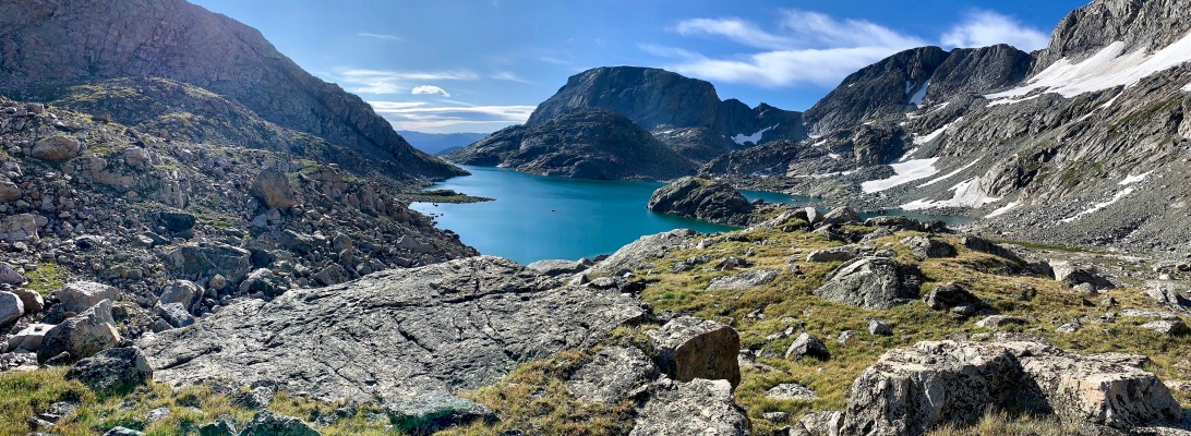
At the top of Eielson we separated along the ridge line and spent close to an hour alone, in solitude. Obviously we wanted some time to ourselves to simply take in and appreciate views which others could only imagine. But more than that, we spent time giving thanks to God for such profound beauty and freedom in the world and in our lives, thanks for the gracious and loving family members who support us and let us use our vacation time for wild and mind-blowing trips, and thanks for the physical ability and outdoor knowledge we have that enables us to go into the wild. When we came back together we took some pictures and then each one of us took turns standing on Eielson’s peak yelling to the top of our lungs “ALASKA!” That was the exclamation mark on one epic and memorable Alaskan adventure.

100_2870IMG_3696

IMG_3698

IMG_3700

IMG_3701

IMG_3704

As we descended along the ridge line we could see storm clouds brewing. On our last day Alaska would not allow for an easy exit… and that certainly became our running joke for the last four hours that day. It was a rough descent down the mountain and it seemed as if we would never reach the river bed. It began to rain so we dropped the packs and rain geared up. It stopped raining so we dropped our gear and took off the rain coats because they were getting too hot. We got ever closer to the river bed and decided to stop for our last blueberry break. We dropped the packs again and devoured pounds of blueberries. Once we hit the river bed it was going to be a long haul to our final destination… and around each bend… there were more bends and more bends. We finally climbed a twenty foot hill to the west of us to get on top of the land mass we were trying to circumvent. Once on top we hit a straight line and probably cut out a mile’s worth of river bed hiking. We descended and finally approached the Thoroughfare River. It was our last crossing and we sized it up. Again Alaska was laughing. Although we all had dry boots and wished to finish with dry boots… there was no way to cross without going at least knee deep. Like three banshees we ran through the Thoroughfare like runners crossing the finish line.

IMG_3707

IMG_3710

IMG_3711

IMG_3715

IMG_3717

IMG_3718

IMG_3720

IMG_3721

IMG_3724

IMG_3725

We finally reached our destination for the night, which was only one mile from Eielson Visitor Center. As we dropped our packs and began to shape up the area the rain began to fall again and we just looked at each other. We were each thinking the same thing- we are only one mile from a bus out of the park, a cozy bed, and a warm meal at a restaurant! We were outta there. Sure we would have liked to brag about 8 days in the Alaskan wilderness, but 7 sounded just fine. The rainy and muddy hike up to the visitor’s center was a cruel joke and one last way Alaska would put the screws on us. This was NOT a leisure trail. It was near vertical and four inches of mud to step through on the horizontals. The weeds were head high and so we bush whacked. By the time we reached the top we were informed by a ranger that they had just spotted a grizzly in the immediate area in which we were hiking. Of course. We waited 15 minutes for a green bus to pick us up. I am sure the people we sat near did not appreciate our looks or smells.

Would I recommend someone backpack in Denali National Park for a week? Absolutely. But only if you have your head straight. While this was the most labor intensive backpacking I have ever done, it was more of a mental challenge than anything. Despite how difficult it was, it was one of the most beautiful and rewarding accomplishments in my life.

An edited, day-by-day version of my adventure in Denali National Park appeared in the fourth issue of Sidewalk – a hiking and backpacking magazine.

Alaska: Muldrow Glacier (Unit 19) to Wolverine Creek (Unit 18) Denali National Park- Day 6

Muldrow Glacier (Unit 19) to Wolverine Creek (Unit 13)

Mileage- 5.1 miles

Elevation Gain- ~500 feet

Elevation Loss- ~500 feet

Day 6 Denali

Day 6 Denali 2On our sixth day in Denali National Park we left Unit 19, crossed the Muldrow Glacier to Green Point (for the second day in a row), and then hiked into Unit 13 to Wolverine Creek just south of Mt. Eielson.

I have to be honest and say that my two favorite days in Denali were days six and seven.  Of course I will write about day seven in the next post, but day six was something else.  We woke up to a few clouds, blue skies, and a warm, radiant sun.  We welcomed it, for sure.  The previous day we were completely soaked and spent much of the evening in our tents.  On this morning we were able to set out all of our wet gear to dry.  We knew that we only had about a five-mile hike so we were cool with getting a later start.  And, despite getting off track the previous day crossing the Muldrow Glacier… we were much more confident  crossing the glacier with a direct route to Green Point this day.

IMG_3576IMG_3598 IMG_3601 IMG_3605 100_2635

This biggest issue with crossing the glacier is when you drop down and lose your line of sight to the end destination. As we planned our crossing, we made mental notes of identifiable landmarks within the glacier that would keep us lined up. I suppose a simple compass would do the same thing, but we are guys right? And who wants to ask for directions when we can find it on our own! 🙂 This approach worked just fine. We stayed lined up as we kept our eyes fixed on our intermediary landmarks. Of course the biggest problem with crossing glaciers is the unpredictability of obstacles. Heading toward Green Point we hardly had any real obstacles except for walking around pools of water and going down steep embankments. All of the elevation we encountered on this day was due to the glacier. My guess is that we were under 500 total feet elevation but it may have been just above that. Either way it was easy elevation.

IMG_3608IMG_3609100_2646 100_2647 IMG_3611 IMG_3612 IMG_3614 IMG_3616100_2668IMG_3623

Once we got to Green Point we followed Glacier Creek north until we saw the base of Eielson to the north.  We travelled eastward and just south of Eielson, which we would be summiting the next morning.  McKinley had been elusive for our first six days either because we were out of range or because the clouds covered her.  The park claims that only 30% of all visitors to the park get a chance to see McKinley.  Our best chance would be on top of Eielson.

IMG_3633 IMG_3637 100_2680 100_2686

We followed fresh water of Wolverine Creek through a rock-bed carve out between mountains where we would be camping for the night.  Despite the fact that we wanted to be done for the day so we could pump and eat, we pressed on so that our hike to the saddle on the southeast side of Eielson would be shorter the next morning.  We would be dropping our gear on the other side of the saddle the next morning so that we could ascend Eielson without much weight on our backs.  Finding a spot to camp along Wolverine Creek was not easy because of the rocks and uneven terrain.  We pressed on until we found a spot that could handle our two tents.

IMG_3649 IMG_3651 IMG_3653 IMG_3658 IMG_3659 100_2712

We pumped, ate, and settled down for a much needed night’s rest to prepare for the 11-mile marathon hike up Mt. Eielson and then out to the Eielson Visitors Center. Our most epic day awaited us.

An edited, day-by-day version of my adventure in Denali National Park appeared in the fourth issue of Sidewalk – a hiking and backpacking magazine.

Alaska: Green Point (Unit 18) Over Muldrow Glacier (Unit 19) Denali National Park- Day 5

Green Point (Unit 18) Over Muldrow Glacier to Unit 19

Mileage- 3.9 miles

Elevation Gain- ~500 feet

Elevation Loss- ~500 feet

Day 5 Denali

Day 5 Denali 2

Crossing the non-technical Muldrow Glacier on our fifth day in Denali National Park was one of the toughest days of our seven.  We had been told at the Backcountry Office that the hike was a relatively easy hike that would take about three hours to cross.  There was a somewhat visible land bridge that connects Unit 18 to Unit 19 via the Muldrow Glacier.  When looking down on the Glacier it looks like a river of pulverized black volcanic rock.  In many respects, it does not look like your textbook glacier.  But it is glorious nonetheless.  But before crossing the glacier we needed to locate fresh water to pump.  Everything we had seen in our camping area was silty glacial melt and un-pumpable.  Fortunately we located a stream from snow melt that ran within a couple hundred yards of our camp.

IMG_3550 IMG_3551 IMG_3552 IMG_3553 IMG_3554

We really didn’t follow good logic on our first pass of the Muldrow Glacier.  Of course we would get another chance the next days as we passed back over, but for this day we made some errors crossing.  Not that any of the errors were really bad, because they weren’t, it is just that we took a longer route than what was necessary.  I guess the upside is that we got a more scenic route, but even with as much experience as we have in the backcountry I am still surprised that we make silly mistakes.  The issue was that, despite having a pretty good game plan for crossing, once we got down in the glacier it was difficult to see our end destination.  Being that there is no such thing as a straight line in the glacier and being that there were more obstacles than you could shake a stick at… we inevitably got off track and took a less direct route to the other side.

IMG_3555

IMG_3556 IMG_3557 IMG_3558 IMG_3559 100_2561

The difficult terrain was degraded because of the predictable Alaskan rain showers.  I hate to admit it… but out of the seven days in the Denali backcountry… this day pushed me very close to my limit.  I think I missed lunch on this day and the hike was longer and harder than I expected it to be.  Add the rain and a cold day on top of it… and I was a bit cranky.  I really regret letting it get to me.  On the bright side… I ate TWO suppers once we made it to the other side!  I was one happy camper for sure.

IMG_3560 IMG_3563 IMG_3564

Ok… well… we all ate TWO DINNERS that day!

IMG_3565 IMG_3566 IMG_3567 IMG_3568 IMG_3571 IMG_3575

The beauty of Unit 19 was that once the clouds passed we could tell that it was going to be a really special place to camp (you will see this in the Day 6 post).  This is the kind of place that really makes you feel like you are out of civilization… just you and nature.  This is the place that makes you feel wild and free among the elements.  You feel so alive.  If you are reading this post and sitting on the fence about whether you should go outside and explore… make up your mind with a “yes” and do it.  You have one life.  Live it.

On Day 6 we will be crossing the Muldrow Glacier (more directly this time) and into a canyon area just south of Mt. Eielson in Unit 13.

An edited, day-by-day version of my adventure in Denali National Park appeared in the fourth issue of Sidewalk – a hiking and backpacking magazine.

Alaska: Grassy Pass to Green Point (Unit 18) Denali National Park- Day 4

Grassy Pass to Green Point (Unit 18)

Mileage- 4.9 miles

Elevation Gain- 0 feet

Elevation Loss- ~300 feet

Day 4 Denali NP 2 Day 4 Denali NP

It was our fourth day and we had just finished our first loop that took us through Stony Creek, Bear Draw, and along the Toklat River to the Toklat Rest Area.  Our day was not finished as we would board a green passenger bus and head west passed Eielson Visitor Center to a place known as Grassy Pass.  This would be the beginning our next 4-day adventure that would take us across the Muldrow Glacier and back, up Mt. Eielson, and then back to the Eielson Visitor Center.

Hiking from Grassy Pass down to the gravel bed was rough.  While there was a “social” trail that we followed, it didn’t seem very social.  It was wildly overgrown and with every step each of our boots were completely submerged in thick mud.  That pretty much sums up each day in Denali.  When you thought that there might be something easy, Alaska always had the last laugh.  There wasn’t anything easy during our week of backpacking.  It was hard and tested each of us mentally- Could we continue to deal with and endure the rain, the cold, the wet feet, the exhausting brush, and every other obstacle thrown our way?  Of course we could.  But it would take some serious mental victories.

Walking across this gravel bar was interesting to say the least.  We spotted some caribou in the distance, as they were grazing and eating.  They hardly noticed us as we were within 60 yards, but then they began to clear out.  Further ahead we saw more caribou (the women and children) also clearing out and heading counter-clockwise and heading in the distance to our left.  As we continued to walk we noticed two male caribou to our two o’clock position probably a quarter mile away.  One of them went clockwise circling around us to our right and then behind us in the distance.  The other caribou stayed directly in front of us… and began aggressively hammering his front hooves as a warning.  There were two problems. The first is that it was rutting season and the males were extra aggressive.  The second was that we needed to go exactly where that caribou was standing.  We were like, “Come on caribou.  Can’t anything be easy here.  Just move along and leave us alone.”  We were forced to swing left a bit to create more distance, but it didn’t seem to matter as the caribou began charging us.  Fortunately the distance between us was still appropriate and it was just warning us… but we picked up a few big rocks that we were ready to chuck if it got any closer.  It finally cleared out in the brush, but it was still in the area we needed to travel.  As we crossed the Thoroughfare River we went through the brush which opened up into a corridor.  Guess who was standing 100 yards away staring at us?  Yup.  He began to charge again… but we started whopping and hollering until he finally cleared out.  We finally saw him in the distance with his bride.  Just protecting his lady.

IMG_3506 IMG_3508 IMG_3510 IMG_3513 IMG_3520

For the remainder of the day we would follow Glacier Creek.  For pumping purposes, we had to be diligent with locating clean water sources.  While there were many creeks and rivers, they were mostly glacial melt and incredibly silty.  The silt can easily destroy water filters.  Fortunately for us with a little searching we found some clean water streams that came from snow melt on top of the mountains.  More on that with the next post.  The sun was finally beginning to break through the clouds and we found a nice grassy patch to lay out all of our wet gear for a quick dry.  I LOVE THOSE MOMENTS!

IMG_3523 IMG_3525 IMG_3527 100_2468 IMG_3532

We continued to hike along Glacier Creek for a couple of miles until everything began to open up.  We set up the tents on a large gravel bar in a beautiful spot with Glacier Creek and mountains all around us.  Just a very short hike up a hill to our west, we could see the Muldrow Glacier and the route we would be taking the next day as we crossed it.

IMG_3543 OLYMPUS DIGITAL CAMERA IMG_3538 IMG_3541 IMG_3545 100_2502IMG_3548

The Muldrow Glacier, while looking like a short, non-technical hike to the other side, is quite deceiving.  On Day 5 it would take us 4.5 hours, as we got off track and did not take the most direct route, and on Day 6 it took us 3 hours.  As we settled down into Unit 18 for the night we knew that traveling to Unit 19 would be a bit challenging.

An edited, day-by-day version of my adventure in Denali National Park appeared in the fourth issue of Sidewalk – a hiking and backpacking magazine.

Alaska: Toklat River (Unit 32) to Toklat River Rest Area (Unit 32) Denali National Park- Day 4

Toklat River (Unit 32) to Toklat River Rest Area

Mileage- 3.4 miles

Elevation Gain- 0

Elevation Loss- 0

Denali NP Day 4 Denali Day 4

We started Day 4 camped on the river bed of the Toklat River in Denali National Park.  Our goal for the day was to backpack to the Toklat River Rest Area, where we would catch a green park bus, and travel to this area west of Eielson Visitor Center called Grassy Pass.  We would then backpack to Unit 18, but more on that in the next post.

Our fourth morning started much like it ended the previous day- rainy.  It was overcast with a misting rain.  We knew that the prospects of staying dry the first half of the day were going to be slim.  Our 3.4 mile hike to the Toklat River Rest Area was riddled with an obstacle course of the braided Toklat.  It wasn’t as easy as picking a side and then walking along the dry river bed.  The Toklat braided from far side to far side.  A person was left with two choices- either do a dozen or so river crossing of various depths – or- go back into the dense brush and bushwhack for 3.4 miles.  We were none to eager to get back into the brush so we prepared for a morning of crossings.

IMG_3489IMG_3492OLYMPUS DIGITAL CAMERA OLYMPUS DIGITAL CAMERA OLYMPUS DIGITAL CAMERA OLYMPUS DIGITAL CAMERA

It is easy to underestimate river crossings.  A person could easily approach a crossing with an unhealthy over-confidence and pay the price with a mistake.  If you have been a regular reader of this blog you will know that we are extremely cautious and conservative when it comes to safety.  All it takes is a split second to be careless or unfocused and it could mean serious injury or death.  When it comes to river crossings a group should work together to consider all possible routes.  Obviously going with the most shallow and slow-moving is preferred, but that is not always possible.  For us there were times when a deep, fast-moving stretch would Y and make a crossing a bit easier.  The truth is that it doesn’t take very deep water to get swept off of your feet, especially when it is fast moving.  The best approach to crossing is to face upstream, lean forward, and cross diagonally to the other side using your trekking poles for extra support.

IMG_3493 IMG_3494 IMG_3495 IMG_3497 IMG_3498

The rest area was within sight we had one crossing that remained… and as much as we studied and tried to consider other routes… there were no other options.  This crossing was thigh high and fast-moving.  Fiesbeck got in by himself initially to see if it was possible and quickly got out.  The current was so strong that he began to be lifted off of his feet.  He said that he even felt large rocks going passed his legs.  We discussed as a group and decided that we would do a four man conga line.  We lined up, held onto the man in front of us, and went for it with Fiesbeck forging the way.  We made it with no issue whatsoever.  The only drawback is that we didn’t get a picture.

IMG_3499 IMG_3500 100_2416 IMG_3502 IMG_3503 IMG_3504 IMG_3505 100_2425

An edited, day-by-day version of my adventure in Denali National Park appeared in the fourth issue of Sidewalk – a hiking and backpacking magazine.

We arrived at the Toklat River Rest Area just before noon and waited for a westward traveling green bus to take us to our next destination.  We would be backpacking across the Muldrow Glacier and then summiting Mt. Eielson to finish our trip.

Alaska: Stony Creek (Unit 39) to Toklat River (Unit 32) Denali National Park- Day 3

Hike from Unit 39 (Stony Creek) to Unit 32 (Toklat River)

Mileage – ~7.5 miles

Elevation Gain- ~500 feet

Elevation Loss- ~500 feet Denali Day 3 NG Denali Day 3 This was our toughest day by far… and we had a feeling that it was going to be.  We knew that the terrain was going to be challenging.  The Unit 39 description on the Denali National Park website states that the route south of Mt. Sheldon to the Toklat River is “gentle but brushy in sections.”  Let’s put an emphasis on “brushy.”  Our immediate challenge, besides the overcast, rainy skies and cool temperatures, was a mix on dense pine trees, tussock tundra, and knee high scrub.  Within eyeshot we could see the saddle over which we would be passing just south of Mt. Sheldon.  The rule when backpacking without trails and only using topographical maps is to know the direction of your end point and then to identify more immediate visual goals that keep you in line with your end point.  By identifying the next goal before proceeding it allows you to stay on track even when you are diverted because of an obstacle.  This was essential for us on this particular day, but even more so on days 5 and 6 when crossing the Muldrow Glacier. OLYMPUS DIGITAL CAMERA IMG_3418 IMG_3419 After breaking out of the brushy stuff our hike was up a couple of hundred gently sloping feet to the Mt. Sheldon saddle.  Don’t worry… as wet, cold, and ticked as I look in the picture below… it wasn’t long after that moment that I said to the guys, “On a scale of 1 to 10 with 10 being the most amazing time of my life… this is an 11!”  Believe me… as difficult as this day was physically… it beats almost anything else you could be doing in your regular, boring life.  Which reminds me, about 90% of backpacking is mental.  Having a negative, pessimistic, and defeated attitude can break even the most physically trained athlete.  That is why I love backpacking so much- It teaches you so much about life and how to endure and press on… even when you are in the most difficult situation. OLYMPUS DIGITAL CAMERA IMG_3421 Our view once we made it to the saddle was… well… disappointing.  More brush.  And more dense brush.  And more rain.  And more wind.  Just over the saddle was a perfect spot for a snack.  I believe that it was at this point that Patrick noted how there is absolutely no place to escape the wind and rain.  No tall trees.  No caves or overhangs.  Just you and the wind and the rain.  So you may as well decide to laugh and love it. IMG_3423 IMG_3429 IMG_3431 At one point we thought that we hit the jackpot by finding a dry creek bed to follow but it was short-lived. We reentered the brush and soon enough approached a marshy area with a couple of small ponds where we took another break. IMG_3433 IMG_3434 IMG_3438 IMG_3439 IMG_3443 It was at this point that we had to make a decision about our route. We were within eyeshot of Sheldon Creek and wondered if the most efficient route to Toklat would be following the creek. After weighing the options, including the distance to get to the creek and then fighting the dense Alders for a mile, we decided to stay with our current route across the tussock tundra, however we would have to fight the Alders occasionally. For any of you who think I have been exaggerating about the difficult conditions, here is a beautiful video illustration of how it really was.

As we were just above the final tree line before making our final descent down to the Toklat, the clouds began to break up and the sun began to peek through. It made for some sweet shots before tackling the roughest patch of this hike called Bear Draw. The trees and brush were so dense that it was almost too difficult to get through. Occasionally we would find a moose trail and follow it for a while before it trailed off to a dead end… and then it was bushwhacking. It seemed as if we would never make it to the bottom. I was growing increasingly weary, but just as I had a thought of stopping we popped right out onto the gravel bar. I can’t think of many trips in which I felt a greater sense of accomplishment than this particular day. It was long. It was hard. It was wet and cold. I immediately began to strip off all of my clothes, just standing in my underwear trying to dry off. The sun felt great. Well, it felt great for 20 minutes… and then began to rain on us the rest of the evening. IMG_3445 IMG_3449 IMG_3450 IMG_3460 IMG_3463 IMG_3471 IMG_3473 IMG_3474 IMG_3475 IMG_3476 IMG_3477 IMG_3480 IMG_3482

An edited, day-by-day version of my adventure in Denali National Park appeared in the fourth issue of Sidewalk – a hiking and backpacking magazine.

In my next post I will talk about Day 4- hiking down the Toklat to the Toklat Rest Area where we would catch the green bus and then beginning our next hike in Units 18, 19, and 13.

Alaska: Unit 39/33 Day Hike (Denali National Park)- Day 2

Day Hike from Unit 39 Campsite up the mountains northeast of Mt. Galen in Unit 33

Mileage â€“ 3.5 miles

Elevation Gain- Approximately 1800 feet

Elevation Loss- Approximately 1800 feet

Denali Day 2 NG

Denali Day 2

I was super excited for Day 2 in Denali National Park, as we would do something that we had never previously done on any of our backpacking trip… take a day hike in Units 39 and into Unit 33. In every other instance we had always packed up at the break of dawn and set out for another destination.  On this day we purposefully set up our permit so that we could keep our tents set up for another day in Unit 39 and just day hike without any significant weight on our backs.  Unit 39 is big enough, in and of itself, for several days of backpacking.  Even a day of day hiking would barely scratch the surface.

Mt. Galen is located in Unit 33 and is a part of the mountains that we were going to climb.  As with every other day in Denali, there were no trails… so we began formulating our route. As a side note, we knew that climbing close to 2000 feet would give us the opportunity to see what route we would take on the morning of Day 4 passed Mt. Sheldon and through the rough Bear Draw.  But Bear Draw would be equally as rough and demanding as the first 200 feet of our day hike.  Before we could get into an area where we could actually begin “hiking,” we had to go near vertical through some of the most dense brush and trees that we encounter on this trip.  The only way we could scale this mountainside was to dig our feet in and pull ourselves up by grabbing trees.  Fortunately this only last about 30 minutes.  Needless to say, we didn’t get any pictures of that adventure.

IMG_3288 IMG_3290 IMG_3293 IMG_3297 IMG_3298OLYMPUS DIGITAL CAMERAIMG_3304

Other than the first two hundred, this was a remarkable hike.  The views, as we were ascending, of the river valley and the mountain ranges were spectacular (you can even see our tents amidst the scrub)… not to mention that we had the perfect August weather- mid 50’s and cool with sun and blue skies.  It is always interesting looking at the terrain from a distance compared to being in that exact terrain.  What I mean by that is from a distance the terrain looks so contoured, pillowy, smooth, and gentle.  It gives you the impression that you can just glide over it without any obstacles or resistance.  And then, once you are in the areas you once viewed as pillowy and gentle, you realize how coarse, rough, hard, and full of resistance and obstacles it actually is.  In many ways, it’s beauty can give one a false sense invincibility- we are the conquerors!  And it welcomes and seduces our naiveté and allows us to believe that we are in control even but for a moment, and then wakes us to our fragile and humble reality that while she is beautiful… she will never be conquered.

IMG_3313 IMG_3314 IMG_3316 IMG_3319 IMG_3322 IMG_3326

It seems as if with every step we could see even more of Denali. Soon enough we were at the height at which we could see Mt. Galen and the other adjoining mountains.  The diversity of terrain was spectacular.  Not just the composition, but the colors.

IMG_3339 IMG_3348 IMG_3349 IMG_3351 IMG_3363 IMG_3371 IMG_3378

We took a long lunch break at the top. I am convinced that place was constructed for relaxing. Soon enough the afternoon storm clouds began to approach RAPIDLY and we decided to descend and stay ahead of it. Well, we just weren’t that fast. We decided that since we were going to be wet anyway that we might as well stop for a much needed blueberry break.

IMG_3386 IMG_3388 IMG_3389 IMG_3398IMG_3405

IMG_3406

IMG_3410

We got back to camp with overcast skies and rain the rest of the evening. We actually turned in early because of the rain, but we also knew that our hardest day was yet to come. We would be passing through Bear Draw and down to the Toklat River.

An edited, day-by-day version of my adventure in Denali National Park appeared in the fourth issue of Sidewalk – a hiking and backpacking magazine.

To read about our previous days in Denali National Park click here.