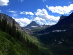
 I had read in at least two spots on the internet that the North Circle Route in Glacier National Park was considered one of the top ten hikes in the world.
Of course after last year’s amazing backcountry hike in Rocky Mountain National Park… we needed something even more challenging and epic.
There was no question the beauty would be second to none. And the more we researched the North Circle Route, we realized this route would certainly meet the “more challenging” part as well.
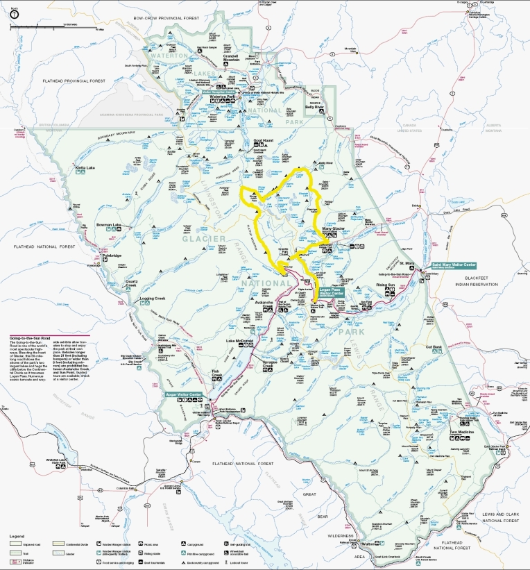
The North Circle route in Glacier National Park is a 65-mile loop trail comprised of Swiftcurrent Pass Trail, Ptarmigan Trail, Stoney Indian Pass Trail, and either Flattop Mountain Trail or Highline Trail. We realized quickly that the “challenging” part of this loop was the minimum of six nights, seven days in the backcountry and packing all of our food for the week. One could certainly do this loop faster and cover more ground daily BUT you would be doing yourself a serious disservice being in one of the most beautiful places on earth only to rush to get to your next location. This is a route that deserves your attention.
After researching and studying North Circle and then selecting the recommended backcountry sites, I began to fill out the mandatory permit application ($30 non-refundable application fee). Being that we would be a group of six, we had to request two backcountry campsites at each stop. This was going to be a bit of a stretch because the Glacier Backcountry Office typically receives over 1200 applications each year. As it turned out in our case, over 1600 applications were received for 2013 during the early application window from January 1st through the middle of March. At some point in May the Backcountry Office began to randomly select and assign the trips.
Even though the beginning point of our itinerary (starting in Waterton Park, Canada and entering through Goat Haunt) did not get approved… we were selected and approved for the entire route with two campsites at every destination. Our beginning point would be Packer’s Roost and then traveling counter-clockwise.
Here is our approved trip itinerary:
Packer’s Roost TH
DAY 1: Granite Park- 5.1 miles 2790 up 0 down
DAY 2: Many Glacier- 7.6 miles 735 up 2255 down
DAY 3: Elizabeth Lake FT- 10.1 miles 2480 up 2518 down
DAY 4: Mokowanis Junction- 8.7 miles 298 up 290 down
DAY 5: Stoney Indian Lake- 5.7 miles 2410 up 1000 down
DAY 6: Kootenai Lake- 5.3 miles 0 up 1975 down
DAY 7: Fifty Mountain- 8.3 miles 2280 up 0 down
DAY 8: Packer’s Roost- 12.0 miles 565 up down 3585 down
As you can surmise from the approved itinerary… instead of getting seven days on the trail… they gave us eight. I think that since they did not give us Waterton… they wanted to give us a nod at Kootenai. Certainly a very nice gesture and very accommodating.
There were only two modifications to our itinerary once we arrived at the Backcountry Office to start our hike. The first is that one of the Rangers recommended that instead of starting at Packer’s Roost and a gargantuan uphill hike, we may enjoy a much more leisurely and picturesque hike from Logan Pass to Granite Park. Yes, the mileage would be greater (close to 8 total miles) but the energy exerted and the views would be worth it. We took that recommendation.
The second modification to our itinerary was caused by the elements, which I will describe in more detail in another post. While at Stoney Indian it rained for 33 hours straight in 45 degrees. One of our tents was in a small depression and pooled two inches of water overnight, which left us scrambling to relocate on a large rock and leaving us soaked in the process. We decided that, as it continued to pour throughout the day, to not chance hypothermia and stay another night at Stoney Indian (foregoing Kootenai). Ugh. This meant that we would leave Stoney Indian and travel directly to Fifty Mountain the next day. This plan, while not ideal, worked out perfectly.
Here is what our actual itinerary ended up being:
Logan Pass TH
DAY 1: Granite Park- 8.0 miles 900 up ? down
DAY 2: Many Glacier- 7.6 miles 735 up 2255 down
DAY 3: Elizabeth Lake FT- 10.1 miles 2480 up 2518 down
DAY 4: Mokowanis Junction- 8.7 miles 298 up 290 down
DAY 5: Stoney Indian Lake- 5.7 miles 2410 up 1000 down
DAY 6: Stoney Indian Lake (TORRENTIAL RAIN DAY)
DAY 7: Fifty Mountain- 8.3 miles 2280 up 0 down
DAY 8: The Loop Parking Lot- 13.0 miles 1000 up 2500 down
Come back to this page over the next couple of weeks and I will be linking each day of the itinerary to a summary of the hike with pictures. I would love to hear your feedback and take your questions as well!
peace…
brandon

2 thoughts on “Montana: Glacier National Park- North Circle Route”